![]()
Archaeology is the ‘science of destruction.’ By excavating an ancient site, archaeologists must destroy buildings, archaeological layers and other features to get down to the next cultural layer. A large part of the history of archaeology since the 19th century is one of excavators striving to achieve better methods of recording their discoveries before they are removed from their original archaeological context. This is because the context of archaeological finds tells the story of their function and role in ancient societies. Removed from their original context, archaeological finds lose much of their significance. Over the past decade, archaeologists have made great strides to incorporate new developments in information technology to achieve the highest level of field data recording.
UCSD archaeologists working with CISA3’s Archaeology group have created a seamless, On-Site Digital Archaeology System using the latest in geographic information systems (GIS), geographic positioning systems (GPS), digital surveying tools, digital photography, and other tools. This on-site recording system greatly facilitates the analyses of archaeological field data, traditional publication as well as its presentation in web-based applications, and the representation of these data in the most advanced visualization environments.
The On-Site Digital Archaeology System was developed during a series of archaeological excavations in the ancient mining and metallurgy district of Faynan in southern Jordan. Working with Dr. Mohammad Najjar of Jordan’s Department of Antiquities, a team led by CISA3 Associate Director for Archaeology and UCSD professor Tom Levy is investigating the role of ancient mining and metal production in societies spanning the Neolithic period to Islamic times (ca. 7500 BCE – 638 – 1099 CE) through a series of large-scale excavations and surveys. UCSD CISA3 archaeologists use a wide variety of digital and portable computer devices to create a portable state of the art digital archaeology field lab. GPS, Total Stations, a digital photography studio and other digital tools are set up temporarily in the village of Quraiyqira in Jordan. By the end of the season, all archaeological data from regional settlement patterns to individual artifacts are rigorously recorded and linked seamlessly into a GIS program.
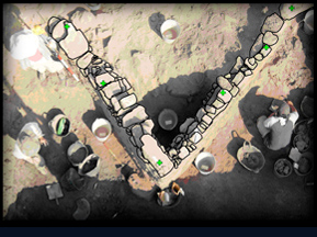
UCSD archaeologists developed a simple method for using geo-referenced digital photographs to draw the ancient walls with the ArcView GIS program
On-Site GIS Digital Archaeology GIS-based Excavation Recording in Southern Jordan

Levy, T. E., and N. G. Smith. 2007. "On-Site Digital Archaeology: GIS-Based Excavation Recording in Southern Jordan," in Crossing Jordan – North American Contributions to the Archaeology of Jordan. Edited by T. E. Levy, M. Daviau, R. Younker, and M. M. Shaer, pp. 47-58. London: Equinox.
